+86-15829664021
liangma0318@gmail.com
- All
- Product Name
- Product Keyword
- Product Model
- Product Summary
- Product Description
- Multi Field Search


1. Detection technology and equipment for mining and excavation at the mining face
Underground seismic exploration technology has achieved remarkable results in detecting hidden disaster-causing bodies such as faults, thin coal belts, and subsidence pillars in coal seams during the coal mining stage. However, there are still some problems in the application process of underground seismic detection technology. The application of explosive seismic sources is limited, it has a certain impact on coal mine production activities during construction, and one-time static detection cannot monitor coal and rock dynamic disasters. The real-time seismic monitoring technology uses the vibrations generated by roadheads (tunnel boring machines) or shearers when cutting coal seams as the seismic source. The echoes of continuous shock waves are used to achieve advanced detection. The online mine seismic monitoring substation can be installed in the underground tunnel for a long time to collect seismic data in real-time and transmit it to the ground through optical fiber. The real-time seismic detection system built on this basis can search for echo signals of abnormal structures from massive seismic data in real-time. And dynamically complete the detection of abnormal geological bodies and dynamic disaster monitoring front and side of the excavation tunnel and in front of the mining working face.
1.1 Real-time seismic monitoring along with mining technology and equipment
Mining seismic is aimed at the mining working face. It uses the signal excited by the shearer when cutting coal as the source signal. It receives the signal in real-time by arranging seismic sensors in the head entry, tail entry, and boreholes of the mining working face, and uses seismic exploration data for real-time processing and dynamic imaging. This technology can achieve precise detection of static geological conditions such as coal seam interruption faults, collapse pillars, and coal seam thinning areas inside the working face, as well as monitoring and early warning of dynamic catastrophic conditions such as roof fracture zones, stress concentration areas, and outburst dangerous areas. And provide data support for intelligent unmanned safe mining of coal mines.
By arranging 450-meter-long seismic sensors at certain intervals along the two troughs of the working face, the vibration signals are continuously received in real-time. Through automatic analysis, the signals excited by the shearer source are identified, and the effective seismic wave field is automatically extracted. Seismic inversion and imaging technology are used to achieve internal imaging of coal mining working faces.

Seismic Construction Layout Drawing with Mining

Seismic Stress Imaging Results with Mining


Seismic Static Structural Imaging with Mining
1.2 Real-time seismic monitoring along with excavation technology and equipment
The vibration signal generated by the road header (tunnel boring machine) cutting the coal wall can be used as the seismic source. The induced seismic waves leave the seismic source and propagate outward. Due to the causative effect of the coal seam, they interfere with each other to form seismic waves and propagate outward along the coal seam. They exist around the head-on encounter. Reflected waves are generated when there are hidden geological anomalies and are received by the deployed seismic sensors. By extracting effective reflected waves from the received wave field and performing reflection imaging, dynamic, intelligent, and fine detection of the geological structure in a certain area in front of the working face of underground coal mine excavation can be achieved, to achieve exploration while digging and efficiently and finely identify the underground mining of coal mines. The purpose of the forward structure is to provide a geological guarantee for the safe and efficient mining of coal resources.
450-meter-long seismic sensors are deployed at certain intervals behind the end of the roadway to continuously receive vibration signals in real-time. Through automatic analysis, the signals excited by the road header are identified, and the effective seismic wave field is automatically extracted. Reflection imaging technology is used to detect geological anomalies within 200 meters in front and side of roadway development.

Imaging Results of Exploration Data with Excavation

Imaging Results of Exploration Data with Excavation
2. Coal mine underground electrical monitoring technology
Automatically collect potential signals in the tunnel of the mining working face, automatically process the monitoring data remotely and online, dynamically monitor the changes in resistivity of the top and floor of the mining working face, and realize real-time monitoring of changes in the hidden water conduction channels near the top and floor of the underground coal mining face.
 Dynamic Monitoring Results Chart of Working Surface Apparent Resistivity
3. Microseismic monitoring technology in coal mines
Through remote data acquisition and automatic data processing technology, microseismic events during the mining process of the working face are monitored in real-time to achieve the goal of monitoring the development of cracks on the top and floor of the mining working face, and the spatial distribution, intensity and frequency characteristics of stress concentration zones.
Microseismic Monitoring Results Map of Working Face
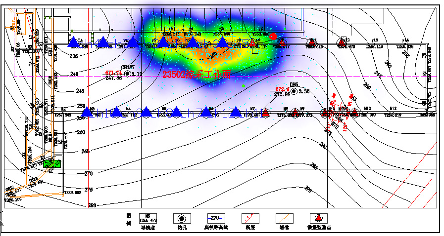
4. Microseismic-electrical intelligent coupling monitoring system
Microseismic-electrical coupling monitoring technology is used to dynamically monitor and evaluate the development of the "two zones" on the roof and floor of the mining working face and the evolution of rock formation fissures. At the same time, the intensity, spatial relative position, geometric fracture size, and concentrated crack development intensity before and after mining are monitored. Through the fusion of multi-parameter and multi-modal data, we can comprehensively evaluate whether the development of cracks in the roof and floor can lead to the aquifer, ensuring safe mining and improving economic benefits.

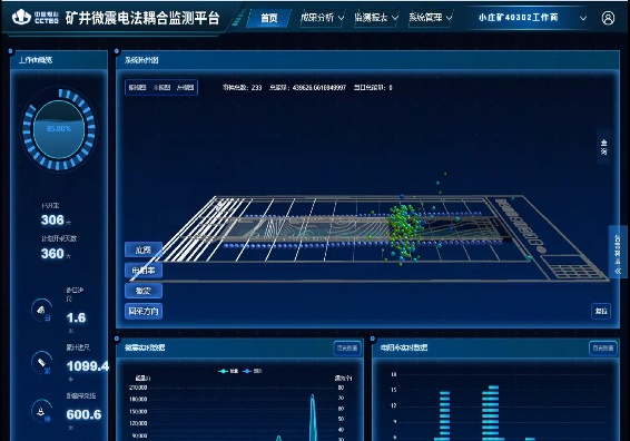

Microseismic-Electrical Coupling Monitoring Results

We have developed microseismic-electrical coupling monitoring technology and equipment, built a multi-intelligence monitoring system for the mining face, and achieved a comprehensive evaluation of the development of the "two zones" on the roof and floor of the mining face and early warning of geological disasters. Through the fusion analysis of multi-source heterogeneous big data, a multi-level early warning mechanism for mine water damage risks is established to realize the automation and intelligence of water damage monitoring and early warning on working surfaces.
5. Geophysical prospecting technology and equipment for long-distance directional drilling
1000-meter directional long borehole by presetting a drilling site behind or adjacent to the rapid tunneling tunnel, using borehole transient electromagnetic, borehole geo-radar, and borehole natural gamma logging technology carries out advanced detection of water-rich areas, geological structures, and lithology in the radial direction of the borehole, thereby forming a detection range with the borehole as the center, a radius of 30 meters, and a depth of nearly 1,000 meters, generating tunneling The high-precision geological prediction profile of the roadway meets the long-distance detection of rapid tunnel excavation.


Borehole Transient Electromagnetic Detection Results


Geological Radar Detection Results Natural Gamma Detection Results
The "long-distance excavation and detection" technology enables long-distance, high-precision geological advanced detection of tunnels, providing a geological basis for safe and rapid tunnel excavation. It can be used to expand applications in multiple dimensions such as geological transparency of coal mining faces, detection of hydraulic fracturing and grouting transformation effects, and emergency rescue and disaster relief.
Grouting Transformation Effect Detection
Hydraulic Fracturing Effect Detection


Comprehensive Processing Cloud Platform

Multi-Source Mine Borehole Geophysical Method Information Fusion Interpretation Platform
6. Electromagnetic detection in holes
With the help of three-dimensional three-component data acquisition and imaging using the electromagnetic method in boreholes, it is possible to detect and predict the precise spatial positioning of low-resistance anomalies within a 30m radial range of the borehole, meeting the needs of "long-distance excavation and detection" for rapid tunnel excavation in coal mines.

Results of Long-Distance In-Hole Electromagnetic Detection Section

Three-dimensional Result Diagram of Long-Distance In-Hole Electromagnetic Detection
7. Precise exploration of ground goaf areas
Ground electromagnetic method fine exploration technology is organically combined with drilling technology, and three-dimensional laser scanning, sonar scanning, in-hole peeking, in-hole electromagnetic detection, etc. are carried out in the boreholes that penetrate the goaf to achieve the delineation of karst caves and goaf areas. And the distribution range of coal/rock pillars, explores the collapse of the roof and floor of the goaf and the height and range of water accumulation in the cavity, to provide a basis for estimating the amount of water accumulation and remaining mineral resource reserves.


Ground Transient Electromagnetic Fine Detection Results Map

Top View of Detection Distribution in Goaf Area
8. High-precision ground-air joint transient electromagnetic method
The joint ground-air transient electromagnetic method is an electromagnetic induction detection method that uses specialized instruments to observe the intensity, spatial, and temporal distribution characteristics of the electromagnetic field generated by underground induced eddy currents on the ground or in the air, and extract and synthesize the electrical information of the target. Analysis, to solve problems such as water richness of aquifers, exploration of goaf areas, or goaf water accumulation areas.
Ground Transient Electromagnetic Method
Ground-to-Air Transient Electromagnetic Method
High Power Transmitter
Done
Receiver
Receive Antenna
As shown in the figure below, the actual exploration results are shown. The three-dimensional imaging results show that the underground medium in the entire survey area is layered, including a total of four layers of media. Subsequently, the three-dimensional imaging body was digitally sliced. Judging from the slice display in the east-west and north-south directions, the electrical layering of the formation is good and the continuity is good, which is consistent with the actual situation of the formation.


Results of Ground-Space Coordinated Time-Domain Electromagnetic Method
9. Accurate detection technology for old empty areas in coal mines
Use ground transient electromagnetic method fine detection technology to delineate the scope of the goaf, provide a target area for drilling, and guide drilling to quickly reveal the goaf (if a coal pillar is hit, the ground hole transient electromagnetic method can be used to further delineate the spatial development of the goaf) layout position), through high-precision three-dimensional scanning technology in the hole, accurate exploration of the goaf in the old coal mine kiln is achieved through continuous tracking.
Combining the respective advantages of ground transient electromagnetic, ground hole transient electromagnetic, drilling, and in-hole laser/sonar methods, the positioning error of the internal structure and specific boundaries of the old kiln goaf is at the sub-meter level, achieving a transformation from conventional qualitative detection results to Explain to precise quantitative and qualitative breakthroughs.
This technology is suitable for the precise exploration of various types of old kiln goaves (with or without water) in coal mines under complex geological conditions and fields such as resource reserve calculation.

Precise Survey and Construction Methods and Equipment for Goaf Area

3D Scanning and Modeling Results of the Goaf Area
10. Fully digital high-density three-dimensional seismic exploration
Three-dimensional seismic exploration technology is an effective technical means for coal mine structural exploration. The fully digital high-density three-dimensional seismic exploration technology integrates the "two wide and one high" processing and interpretation technology, which significantly improves the vertical and horizontal resolution of seismic data and can effectively solve small problems. Detection problems such as faults, subsidence pillars, the extent of sand body occurrence on coal seam roofs, and the interface shape of the ash roof ensure the safe production of coal mines.

Three-Dimensional Display of Coal Seam Floor

Coal Seam Occurrence Change Section Morphology and Fault Display

Seismic Characteristics of Collapse Pillars Developed in Coal Seams

Characteristics of Seismic Planar Properties of Ancient River Channels
11. Channel wave detection technology
Use channel wave detection technology to detect various geological structures inside the mine working face and on the side of the tunnel: small faults, collapse pillars, coal seam bifurcation and thinning zones, magmatic rocks, fire areas, and other geological anomalies.

Transmission Channel Wave Method to Detect Faults

Reflection Channel Wave Method to Detect Faults

CT Imaging of Crater Penetration Detection (Red and Yellow are Abnormal Areas of Crater Penetration Detection, Blue is Normal Areas)

Channel Wave Velocity CT Imaging (Black is the Boundary of the Channel Wave Detection Collapse Column, Red is the Boundary of Mining Exposure)

The Tunnel Boring Head of the Working Face Detects Faults

Transmission Channel Wave Method to Detect Coal Thickness


