+86-15829664021
liangma0318@gmail.com
- All
- Product Name
- Product Keyword
- Product Model
- Product Summary
- Product Description
- Multi Field Search

Views: 0 Author: Site Editor Publish Time: 2025-08-26 Origin: Site
The definition of borehole survey is the process of checking and studying what lies inside a deep, narrow hole drilled into the ground. Using specialized tools, experts gather information as they descend. Understanding the definition of borehole survey helps you grasp how professionals examine underground layers in fields like geology and engineering. Knowing the definition of borehole survey is essential because:
It shows how experts collect critical data.
It explains why these surveys are necessary for safe and successful projects.
A borehole survey looks under the ground. It uses special tools to collect real data from deep holes.
These surveys help experts study soil, rock, water, and borehole direction. This makes projects safer and more successful in engineering, mining, and environmental work.
Using good tools and methods like directional surveying and geophysical logging gives better data. It also helps stop expensive mistakes.
Borehole surveys give detailed underground information. Surface tests cannot do this. They are important for planning, safety, and protecting the environment.
Checking tools, working with experts, and using new technology help you get better results. This helps you make smarter choices in your projects.
A borehole survey helps you learn what is under the ground. The definition of borehole survey means you collect facts from a drilled hole. It lets you know the borehole's spot, shape, and what is below. You use special tools to get data as you go down. This process shows you what is under the surface. You can see soil layers, rock types, and water levels. The survey checks if the borehole is in the right place. It helps you stop problems when building or drilling.
A borehole survey gives you real data from inside the hole. You get clear records of physical and chemical things. This way gives more details than tests done at the surface.
Borehole surveys are used in geology and engineering. They help you make safe foundations and plan earthwork. They also help you check groundwater. You need a good borehole survey to keep your project safe and steady. The definition of borehole survey also means you write down and report what you find for later.
There are many key features in a borehole survey. These features help you collect, study, and use data from the hole. Here are some important parts:
Data Collection: You gather direction data like azimuth, tilt, and borehole spot. You use tools like gyroscopic sensors, magnetic compasses, and inclinometers.
Survey Instruments: You use exact tools to measure the borehole spot and path.
Data Analysis and Correction: You use math to fix mistakes, like magnetic errors.
Survey Program Design: You set goals, look at risks, and plan for surprises.
Operational Implementation: You work with engineers, drillers, and techs. You check data quality and follow steps.
Data Interpretation: You use error models and computer tests to lower mistakes in results.
Modeling and Simulations: You use software to plan borehole spots and guess well paths.
Reporting and Documentation: You make reports with measurements, times, and tool info.
Compliance and Verification: You follow rules and have experts check the survey.
Archiving and Retrieval: You save survey data safely so you can find it later.
Technological Advancements: You use live systems and new software for 3D pictures.
Health, Safety, and Environmental Considerations: You follow safety rules and train workers.
You collect many kinds of data in a borehole survey. Here is a table that shows common data types:
Data Type | Description |
|---|---|
Groundwater Measurements | Water level, height, temperature, date/time |
Borehole Survey Data | Changes, width, rock details |
Drilling Details | Methods, drill runs, borehole spot |
Stratigraphy | Soil and rock layer details |
Discontinuities | Cracks, problems in rock |
Instrumentation Data | Well checks, piezometer readings |
Field Tests | SPT hits, control tests |
Samples | Soil and rock samples |
Comments | Notes about depth |
You use borehole surveys to check well casing, record building, and find water zones. You can see cracks, blocks, and changes in the hole. The survey helps you follow rules and keep quality high. You watch camera checks, reset depth marks, and check recorders. You plan data collection to look both down and up for better images.
Borehole surveys are not like other subsurface ways. You get direct, steady data from inside the hole. You measure things like porosity, permeability, and fluid amount. You can collect many logs at once for a full picture. Other ways only give you surface or near-surface data. Borehole surveys give you exact depth and clear results.
You use the definition of borehole survey to help your work in engineering and geology. It helps you know soil strength, shape, and groundwater. You use this to design safe buildings and plan earthwork. You need borehole spot data for building permits and repair jobs. You do surveys in steps, from simple checks to deep study. You keep checking results during building to match real site facts.

Borehole surveying uses a few main ways to study underground. Each way gives you different facts about the borehole's path and what is below. You must pick the best method and tools for your job. Your choice depends on the rock, the tools, and your goals.
Directional surveying helps you follow the borehole as you drill. You want to see if it goes where you planned. This way uses special tools to check angle, direction, and depth at many spots. You can use gyroscopes, magnetometers, and accelerometers. These tools work together to give you live data about the borehole's place.
Tip: If you use non-magnetic tools like gyroscopes, you avoid mistakes from metal or the earth's magnetic pull.
You follow these steps: First, measure the borehole's tilt, direction, and depth. Next, use non-magnetic tools to stop errors. Then, check and set your tools often. After that, use math to fix any borehole drift. Compare your data with other sources to check quality. Train your team to use the tools and read the results.
Directional surveying keeps the borehole on track. It helps you stop big mistakes and makes sure the borehole matches your plan.
Geophysical logging gives you a close look at rocks, soil, and water around the borehole. You lower sensors into the hole to measure sound, electricity, and radiation. Each log type tells you something new about the ground.
Here is a table that shows common geophysical logging types and what they check:
Logging Type | What It Measures | What You Learn |
|---|---|---|
Acoustic Logging | Sound waves | Porosity, fractures, rock type |
Electrical Logging | Resistivity, conductivity | Water zones, rock layers, salinity |
Nuclear Logging | Gamma rays, neutrons | Rock density, fluid content |
Caliper Logging | Borehole diameter | Borehole condition, stability |
Flow Logging | Water movement | Flow zones, well performance |
You use these logs to find water or oil, check rock strength, spot cracks, and plan safe drilling.
Geophysical logging helps many jobs. It lets you make better choices when drilling. You can use wireline logging, logging while drilling, or vertical seismic profiling. Each way gives you a new look at the ground.
You need the right tools to get good results. These tools are sensors, cameras, and software. They help you collect, save, and study data from the borehole. Good tools make your survey more trustworthy.
Some common borehole survey tools are:
Measurement While Drilling (MWD) systems: They use gyroscopes, magnetometers, and accelerometers to track in real time.
Caliper tools: They check the borehole's width.
Sonic tools: They test porosity and water layers.
Multi-parameter tools: They gather gamma, temperature, and electric logs.
Cameras: They let you see the borehole wall.
Modern borehole gear now has digital systems. For example, Ranger RIGS™ lets you see live sensor data from your rig. You can watch depth, pressure, and more from anywhere using cloud tech. RSLog by Rocscience helps you handle and study borehole data fast. It links your field data to software, making your work quicker and more exact.
CCTEG Xi'an is a leader in this area. It gives top safety tech and borehole drilling gear. Their tools help you stay safe and get better data during borehole surveys. If you want to know more about their advanced gear, contact their team.
Note: Always check your tools before and after each survey. High-precision tools, like true north seeking gyros, cut down mistakes and help you keep the borehole on course.
How you collect data and set up tools matters a lot. If you use bad tools or skip checks, you can get wrong borehole spots and bad survey results. Good tools and careful checks help you avoid big mistakes and keep your project safe.

Borehole surveys help find oil and gas underground. They show deep rock layers and changes as they happen. Vertical Seismic Profiling gives clear pictures of faults and rocks. This helps plan drilling and avoid dangers. New tools like distributed acoustic sensing give better data. Usually, drilling stops every 90 feet for a survey. Now, new ways let you collect data while drilling. In the Caspian Sea, teams did over 100 surveys without stopping. This made work safer and faster.
Here are some good things about borehole seismic surveys in oil and gas:
You get direct data from inside the ground.
You see waves going up and down, so data is better.
You cut down noise from wind or people.
You can watch and check reservoirs for better results.
You use live data to guide drilling and stop problems.
You match well logs with surface data to plan better.
You can watch the reservoir change over time.
Mining uses borehole surveys to find minerals and keep work safe. These surveys give facts about rocks, cracks, and minerals. The data shows how much mineral is there and where to dig. Borehole surveys help teams get more resources and lower harm to nature. Technology makes data collection quicker and more exact.
Industry / Sector | Use of Borehole Surveys | Market Size Estimates and Growth Projections |
|---|---|---|
Mining | Mineral exploration, identifying mineral deposits | Market driven by mineral demand; part of $350M (2023) to $580M (2032) growth |
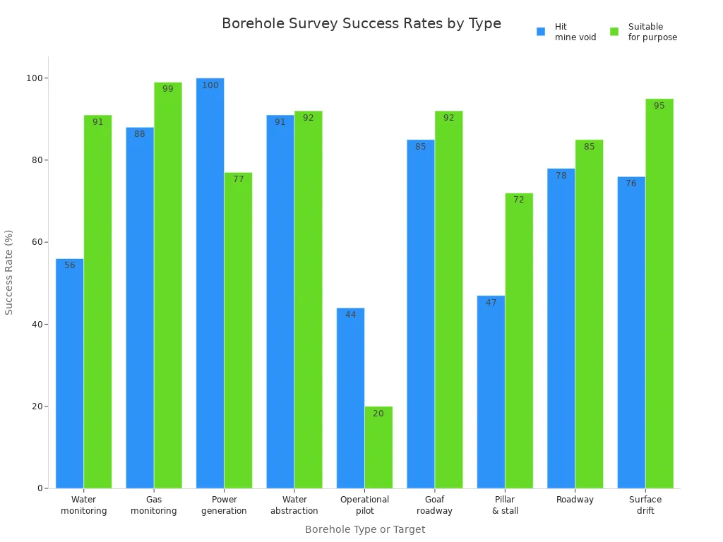
Projects with borehole surveys often do well. For example, 87% of boreholes in mines work as planned. Water and gas boreholes also show good results.

Borehole surveys help check soil and water for pollution. They let you take samples and measure if there is contamination. You drill boreholes in Phase II Environmental Site Assessments to see if a place is safe. If you find pollution, you use the data to plan cleanup. After cleaning, you test again to make sure it is safe.
Rules say you must report boreholes deeper than 15 meters and keep records. You may need a license to use water or throw away waste. Agencies use borehole surveys to watch groundwater, manage resources, and protect nature.
Borehole surveys cost $15 to $30 per foot, depending on the ground and job. Total costs can be a few thousand dollars for small wells or over $100,000 for big projects.
Now you know what a borehole survey is and why it is important. It helps you get key facts about what is under the ground. This makes your work safer and more correct. Some main ideas are knowing how borehole and corehole drilling are not the same, picking the best tools, and not making simple errors.
Borehole surveys help in mining, oil, and checking the environment.
New tools like acoustic televiewers make work safer and give better data.
To use this knowledge, check your tools, talk with experts, and keep learning new ways. Doing this will help you choose better and get good results.
You use a borehole survey to find out what lies below the ground. It helps you collect real data about soil, rocks, and water. This information keeps your project safe and successful.
You look at your project needs, ground type, and budget. Some jobs need detailed rock data. Others need to track the borehole's path. You pick tools and methods that match your goals.
You use tools like gyroscopes, cameras, and sensors. These tools help you measure direction, depth, and rock types. Some projects use digital systems for live data.
Tip: Always check your tools before and after each survey. This keeps your data accurate.
You use it to test soil and water for pollution. It helps you find safe spots and plan cleanups. Agencies use your survey data to protect nature.
Yes! You use them to find minerals, oil, and gas. They show you where to drill and help you avoid dangers. Borehole surveys make your work safer and more efficient.