+86-15829664021
liangma0318@gmail.com
- All
- Product Name
- Product Keyword
- Product Model
- Product Summary
- Product Description
- Multi Field Search


| Quantity: | |
|---|---|
The YSDC(A) measuring instrument represents a critical advancement for underground excavation and geological assessment. It uses electromagnetic wave signal transmission to display the two-dimensional and three-dimensional trajectory graphics of the borehole as well as depth, inclination, azimuth, and other data in real-time. It has the characteristics of a high signal transmission rate, short measurement time, and no special requirements for drilling tools. It can be equipped with directional drilling rigs, and can also be equipped with conventional rotary drilling rigs to achieve real-time trajectory measurement and transmission, making conventional drilling "visible", shortening the drainage cycle, and serving intelligent mine construction.
The instrument excels in its measurement performance and accuracy. Utilizing highly efficient electromagnetic wave signal transmission, it bypasses the delays associated with traditional wired or mud-pulse telemetry systems. This rapid data acquisition means the measurement time is exceptionally short, allowing drilling crews to maintain a steady pace of work without long pauses for surveying. The real-time acquisition of depth, inclination, and azimuth data is processed instantly, rendering precise 2D and 3D models on the display unit. This level of accuracy is paramount for maintaining the intended drill path, especially when navigating complex geological formations where deviations can lead to costly rework.
Beyond the core parameters, the physical construction of this device is engineered for the harsh realities of subterranean operations. The outer casing is forged from thick, heavy-duty metallic alloys, providing a cold, solid tactile feel that immediately communicates its structural integrity and durability. This rugged exterior is specifically sealed with industrial-grade gaskets to prevent the ingress of fine coal dust and pervasive underground moisture. When active, the internal components emit a very faint, consistent hum—a subtle auditory indicator of the powerful electromagnetic signals penetrating through solid rock strata. The visual interface is designed with a high-contrast, anti-glare screen, ensuring that operators can instantly read complex trajectory graphs and numerical data without straining their eyes in the poorly lit, confined spaces of a mine shaft.
Integrating this measuring instrument into existing workflows requires minimal adaptation and offers immediate operational improvements. Because the system operates independently of specific drill string configurations, project managers can deploy it across a diverse fleet of machinery. Whether attached to specialized directional setups or standard rotary units, the device delivers consistent, reliable data streams. This universal compatibility significantly lowers the barrier to upgrading legacy equipment. By transforming blind drilling into a fully monitored, visible process, operators can make immediate course corrections. This precise control directly translates to operational efficiency, drastically reducing the time spent on trial-and-error drilling, minimizing wasted energy, and ultimately lowering the comprehensive construction costs for large-scale mining enterprises.
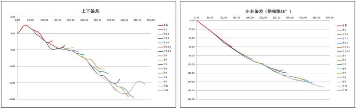
To fully support the rigorous demands of modern intelligent mine construction, the YSDC(A) instrument is built to adhere to strict safety and performance dimensions. The following breakdown details how the device performs under pressure and where it is most effectively deployed to maximize project outcomes.
Intrinsically Safe Design: Operating in environments where combustible gases are a constant threat requires absolute compliance with industry safety standards. The internal circuitry of this instrument is meticulously isolated and engineered to prevent any electrical sparking or excessive thermal output, ensuring full explosion-proof and intrinsically safe certification for hazardous underground zones.
Harsh Condition Adaptability: Subterranean drilling sites are characterized by extreme challenges, including high levels of airborne particulate matter, dripping water, and intense mechanical vibrations from adjacent heavy machinery. The advanced anti-interference electromagnetic wave technology maintains a stable signal lock despite these disruptions, ensuring continuous, rapid data transmission without signal degradation or loss.
The precise data collection capabilities of this instrument make it an indispensable asset across several critical underground applications. By providing a clear, real-time picture of the borehole trajectory, it empowers engineering teams to execute complex drilling plans with absolute confidence.
| Application Area | Operational Value and Impact |
|---|---|
| Coal Mine Gas Drainage | Accurate trajectory mapping ensures that drainage boreholes intersect the target gas pockets precisely. This minimizes the risk of missed targets, significantly accelerating the gas extraction process, improving overall mine safety before excavation begins, and reducing the idle time of the workforce waiting for gas clearance. |
| Water Exploration and Discharge | When probing for hidden aquifers or flooded abandoned workings, the real-time depth and inclination data allow operators to safely navigate the drill bit. This prevents accidental breaches and allows for controlled water discharge, protecting the main shafts from sudden inundation and avoiding catastrophic equipment damage. |
| Advanced Geological Prospecting | For mapping fault lines, rock strata transitions, and mineral veins, the 3D visualization capabilities provide geologists with a highly accurate model of the subsurface structure. This facilitates better long-term planning, optimizes resource management, and ensures that subsequent extraction phases are based on reliable, empirical data rather than estimations. |
From an economic perspective, the implementation of this measuring instrument yields substantial returns. By significantly shortening the gas drainage and exploration cycles, it accelerates the overall timeline of mine development. Enhancing the efficiency of single-hole operations means fewer resources are expended per meter drilled. The reduction in drilling errors and the avoidance of dry holes or misaligned trajectories directly lower the comprehensive construction costs, proving the device to be a financially sound investment for forward-looking mining operations focused on long-term profitability and safety.


