+86-15829664021
liangma0318@gmail.com
- All
- Product Name
- Product Keyword
- Product Model
- Product Summary
- Product Description
- Multi Field Search


Views: 0 Author: Site Editor Publish Time: 2026-10-14 Origin: Site
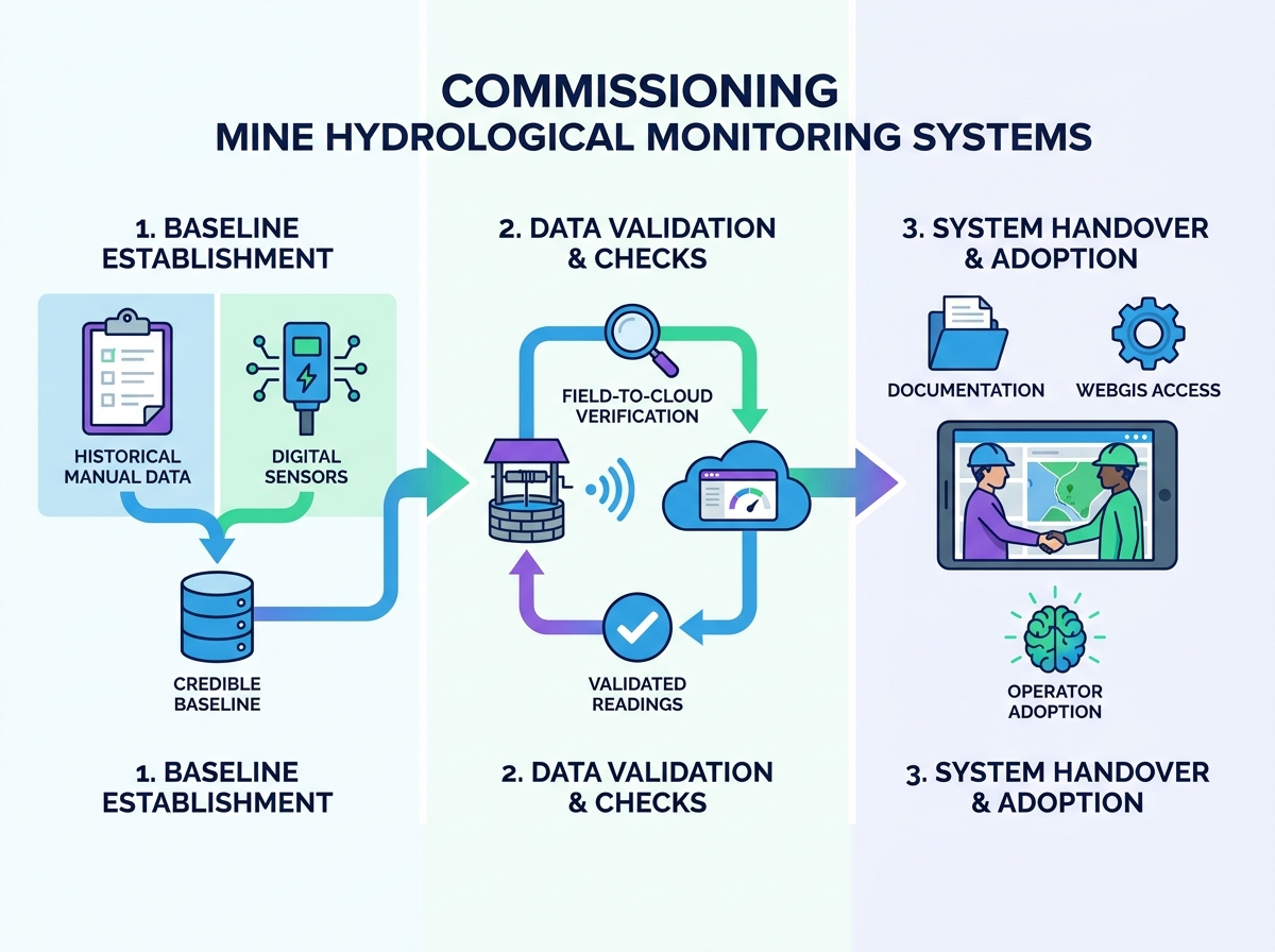
Installing monitoring hardware represents only the first step in digital water management. True value emerges during the rigorous commissioning phase. This critical process transforms raw physical infrastructure into a trusted, compliance-grade asset. Unfortunately, mine operators frequently struggle with intense "black box" anxiety during this transition. They constantly doubt data validity due to rushed handovers, hidden sensor flaws, or mismatched baseline integrations. Prematurely accepting an unverified network often triggers false anomaly alerts. It strains regulatory relationships and causes costly operational disruptions. You need a highly structured approach to prevent these outcomes. We provide a vendor-neutral, systematic framework for commissioning, validating, and taking full ownership of your site network. You will learn how to establish secure ground-truth baselines. We also show you how to stress-test data streams and execute a flawless handover.
Commissioning must bridge the gap between historical manual data and new digital telemetry to establish credible baselines.
Rigorous data checks require physical-to-cloud validation of hydrological sensor readings to rule out telemetry latency or calibration errors.
A successful handover requires transparent documentation, WebGIS access protocols, and transitioning site teams from data collectors to data analysts.
Hydrological monitoring upgrades should prioritize interoperability, avoiding proprietary lock-in during the transition period.
You invite operational risk if you accept a system prematurely. Engineers frequently mistrust automated dashboards if they skip standardized validation. This mistrust defines the "black box" anxiety. Unverified data streams easily generate false anomaly alerts. These alerts trigger unnecessary emergency responses. They disrupt daily mining operations. Poor validation also leads to regulatory non-compliance. Groundwater agencies require accurate, unbroken data logs. You must prove your new system meets strict operational standards before finalizing any vendor contract.
You cannot commission a system based on "good enough" impressions. You must define quantitative success criteria. Determine exactly what "ready for production" means for your specific site. This prevents lingering technical debt.
Telemetry Uptime: Demand 99% connectivity over a continuous 14-day evaluation period.
Data Integrity: Require zero data packet loss between the logger and the cloud server.
Alert Validation: Trigger mechanical limit switches intentionally. Confirm the system dispatches accurate SMS or email alerts instantly.
Modern mine hydrological monitoring systems must align directly with regional environmental protection guidelines. Check the system's reporting frequency capabilities. Some local agencies demand hourly water level updates. Others require daily averages. Your new platform must format data exports to match agency submission templates. Closure-stage mandates impose even stricter rules. Regulators expect long-term data stability during mine closure. A fully commissioned system guarantees seamless compliance reporting from day one.
A shiny new dashboard holds zero value if it contradicts historical site reality. You must bridge the gap between past records and future digital streams. This requires meticulous historical integration.
Mine sites often possess decades of manual dip-meter records. You must reconcile these legacy logs with your newly established digital baseline. Plot the first 30 days of automated data against your historical manual trend lines. Look for abrupt deviations. If the digital curve shifts suddenly from historical averages, you must investigate immediately. Do not automatically trust the new sensor.
Most active mines utilize complex groundwater simulation models. Commissioning offers a perfect opportunity to test them. Feed your initial digital data into these existing simulation models. Check for expected versus actual variance. The newly acquired high-frequency data should ideally validate your predictive models. If the variance remains excessively high, you face a critical decision. You either recalibrate your hydrogeological model or re-evaluate the sensor deployment.
Baseline establishment timing carries significant risk. Failing to account for seasonal variations skews your entire dataset. If you establish a baseline during peak monsoon season, dry season readings will constantly trigger low-level alarms. Active dewatering impacts also distort initial readings. You must log active pumping schedules during the baseline validation window. This context prevents you from misinterpreting a planned drawdown as an environmental anomaly.
Discrepancies happen constantly. You must acknowledge that baseline variations are completely normal. The key lies in your investigation protocol. Determine whether the variance stems from a sensor error or a newly discovered hydrogeological reality. High-frequency digital logging often reveals micro-fluctuations. Manual dipping misses these nuances entirely.
Baseline Reconciliation Matrix
Discrepancy Type | Potential Cause | Validation Action | Resolution Path |
|---|---|---|---|
Constant Offset | Incorrect reference elevation | Survey top-of-casing manually | Adjust offset in WebGIS |
Erratic Spikes | Pump vibration interference | Check pumping schedules | Install stilling well / dampener |
Gradual Drift | Mineral scaling on sensor | Pull and inspect physical unit | Clean sensor and recalibrate |
Delayed Response | Clogged piezometer filter | Perform slug test | Redevelop the monitoring well |
You cannot blindly trust a screen. Hardware fails. Networks drop. Sensors drift. Rigorous stress-testing proves system reliability under harsh mining conditions. This stage transforms assumptions into hard engineering facts.
You must mandate a physical field-to-cloud verification protocol. Deploy technicians to physically measure well depths using calibrated dip tapes. Compare these manual figures simultaneously to the WebGIS dashboard outputs. You must verify these hydrological sensor readings under various conditions. Perform checks during static water levels. Repeat the process during active drawdown events. This rules out telemetry latency. It also catches fundamental calibration errors before they pollute your database.
Mine environments actively attack sensitive equipment. You must check for localized variables that skew data continuously. Submersible pumps generate intense mechanical vibrations. These vibrations mimic false pressure changes in unshielded transducers. Highly mineralized groundwater causes rapid scaling on vibrating wire piezometers. This buildup alters readings over mere weeks. Furthermore, non-vented absolute pressure sensors require precise barometric pressure compensation. If the surface barometer fails or lags, subsurface water level calculations become entirely invalid. Check your barometric compensation algorithms thoroughly.
Data transmission lines break constantly in active mining zones. Heavy machinery severs cables. Poor weather knocks out cellular towers. You must simulate localized power losses intentionally. Disconnect a solar panel. Drop the local network connection. Evaluate the system's local data logging capabilities. A robust setup stores records internally during the outage. Once you restore power, verify the cloud recovery sequence. The system must backfill the missing cloud data automatically without duplicating existing records.
Legacy systems eventually reach obsolescence. However, completely ripping out old infrastructure halts compliance reporting. You face critical architectural decisions during a major transition.
You must decide between integration and replacement. One option involves bolting modern IoT sensors onto legacy SCADA systems. This preserves your existing centralized control room. The alternative requires deploying parallel, independent cloud-based networks. Cloud networks offer superior remote accessibility. They bypass outdated local servers entirely. However, they demand entirely new IT security reviews. Choose the path that matches your internal IT capacity.
You cannot pause regulatory reporting while upgrading equipment. Develop clear strategies for maintaining data continuity during the crossover period. You must run manual and digital systems concurrently for at least one full reporting cycle. If you execute large-scale hydrological monitoring upgrades, leave legacy sensors in place until the new IoT nodes prove 100% reliable. Concurrent monitoring prevents catastrophic data gaps.
Operators frequently focus too heavily on shiny hardware specifications. This represents a strategic mistake. You must evaluate vendors based on API openness. Ask them how easily you can export your data. Prioritize true data portability. Proprietary lock-in traps your operations. If a vendor uses closed data formats, you cannot feed their readings into third-party geological models. Ensure your upgrade path guarantees full data ownership. Your team must control the backend database access directly.
Installation ends when the vendor packs their tools. Commissioning ends when your site team confidently assumes control. A sloppy handover ruins a perfect technical installation. You must formalize this transfer of power.
Do not sign the final acceptance certificate without complete documentation. Demand a standardized handover package.
Calibration Certificates: Secure factory calibration sheets for every installed sensor.
Network Topology Maps: Map exactly where every node, gateway, and repeater sits geographically.
OEM Troubleshooting Guides: Collect original equipment manufacturer manuals for component-level repairs.
API Documentation: Store the developer guides required for future software integrations.
Missing documentation guarantees future maintenance nightmares. It forces your team to rely on expensive vendor support calls for minor issues.
New technology demands a new workforce mindset. You must shift your site teams from manual data collectors to strategic data analysts. They no longer spend six hours driving to remote wells. Train your site hydrogeologists to utilize automated dashboards effectively. Teach them how to set custom alarm thresholds. Show them how to export bulk data for predictive modeling. They should spend their day interpreting trends, not sorting messy Excel spreadsheets. Adoption fails if users feel intimidated by the interface.
Set realistic assumptions about hardware lifespan. Sensors degrade eventually. Establish a rigid, calendar-based maintenance schedule immediately upon handover.
Schedule physical cleaning of submerged sensors quarterly.
Mandate annual recalibration for critical compliance nodes.
Assign software patch management duties to an internal IT liaison.
A proactive QA/QC framework protects your investment. It ensures the system remains as accurate in year five as it was on day one.
Commissioning serves as a vital risk-mitigation exercise. It represents far more than a simple technical formality. Skipping this phase exposes your mining operation to hidden data errors and massive regulatory fines. You must bridge the gap between historical baselines and modern digital realities. Stress-test your hardware relentlessly under real-world conditions. Demand comprehensive documentation before signing any final approvals.
Your next step requires proactive contract management. Advise your decision-makers to act before purchasing equipment. You must mandate strict commissioning protocols in your vendor Service Level Agreements (SLAs). Build data-check milestones into the payment schedule. Do not release final procurement funds until the vendor proves baseline accuracy and system resilience. Take control of the handover process, and your hydrological network will deliver long-term, compliance-grade reliability.
A: A standard baseline validation period should last between 14 to 30 days. You must run parallel monitoring phases during this window. Collect manual dip-meter readings alongside the new automated telemetry. This duration captures enough natural fluctuation to confirm the sensor tracks accurately against real-world environmental changes.
A: First, do not immediately discard the digital data. Investigate physical factors. Check the sensor calibration against factory standards. Next, verify the barometric compensation formula if using unvented sensors. Finally, manually survey the top-of-casing elevation. Often, digital sensors expose micro-fluctuations or historical human measurement errors.
A: The most severe risk involves data continuity gaps. Taking systems offline jeopardizes regulatory compliance. You must run old and new systems concurrently. Another major risk is proprietary data silos. Avoid vendors who lock your data inside closed software ecosystems. You must ensure open API access.