+86-15829664021
liangma0318@gmail.com
- All
- Product Name
- Product Keyword
- Product Model
- Product Summary
- Product Description
- Multi Field Search


Views: 0 Author: Site Editor Publish Time: 2026-08-03 Origin: Site
Coal exploration and extraction carry incredibly high stakes. Inaccurate borehole data routinely leads to disastrous outcomes for operators. You might miss valuable coal seams entirely during the drilling process. Worse, you could accidentally intersect dangerous, historically abandoned mine workings. These spatial errors always cause costly operational delays. They also directly threaten front-line miner safety. To prevent this, operations rely heavily on comprehensive data collection. A standardized survey report acts as the critical bridge here. It transforms raw field measurements into highly actionable mine planning insights. Without it, engineers essentially navigate complex geologies blindly. This article outlines the essential components every compliant report must contain. We will explore exactly how your choice of survey technology dictates final data reliability. You will learn what separates an adequate report from a definitive, risk-reducing document. Accurate reporting is no longer just a best practice. It is a strict regulatory necessity worldwide. Read on to discover the exact benchmarks your next survey report must meet.
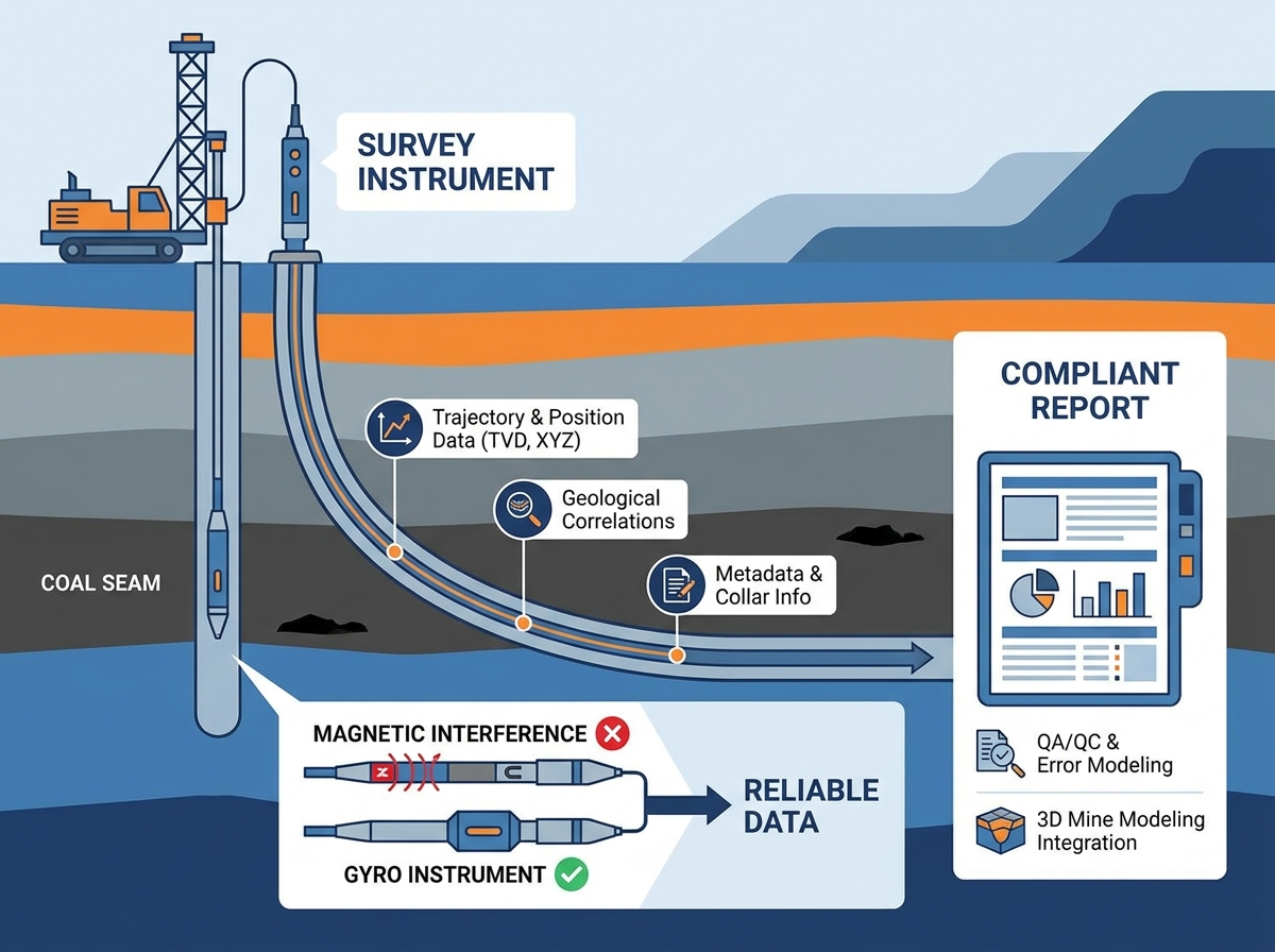
A comprehensive report must include verifiable metadata, continuous trajectory logs, and precise True Vertical Depth (TVD) calculations.
The accuracy of the report is fundamentally limited by the borehole survey instruments used; intrinsic safety and magnetic interference resistance are non-negotiable in coal environments.
Proper documentation of calibration, error modeling (ellipse of uncertainty), and Quality Assurance/Quality Control (QA/QC) separates a definitive report from an unreliable one.
Deviating boreholes create massive financial and safety liabilities for coal operations. Drill bits rarely travel in a perfectly straight line. They deflect off hard rock layers. They spiral due to rotation forces. If left unmeasured, you risk drilling completely outside the target coal seam. Sometimes, a wayward drill bit hits unexpected geological faults. In worst-case scenarios, it breaches dangerously flooded goafs. These sudden water inundations pose immediate threats to underground personnel.
A high-quality report solves these exact challenges. It provides mine planners an exact spatial understanding of the subsurface. They use this verified data to design completely safe panel layouts. It also allows them to estimate minable reserves accurately. Regulatory bodies demand strict compliance regarding boundary limits. Precise reporting ensures you never mine outside your permitted lease areas.
However, we must evaluate these reports through a practical, software-driven lens. A survey report only proves useful if you can seamlessly integrate its data. The information must flow directly into standard 3D mine modeling software. Industry-standard programs like Vulcan or Surpac require clean, rigidly formatted inputs. If geologists must manually scrub or reformat the data first, the report fails its primary purpose. Manual data entry introduces human error. It also wastes valuable engineering hours. A definitive report arrives ready for immediate digital integration.
Every professional borehole report follows a strict structural hierarchy. Missing any single component renders the entire dataset questionable. Auditors look for three specific categories of information when reviewing these documents.
The collar is the physical starting point of the borehole at the surface. If you record the collar incorrectly, the entire subsequent trajectory becomes useless. The report must clearly state exactly where the hole began.
Precise Collar Coordinates: The surveyor must list the exact Easting, Northing, and Elevation. They must tie these coordinates directly to the mine’s specific local grid.
Temporal Data: The exact date and time of the survey provide crucial context.
Personnel Credentials: The document must identify the lead surveyor. It should list their professional certifications.
Contractor Details: You need a record of the specific drilling contractor involved. This ensures accountability if mechanical issues arise later.
This section forms the core mathematical heart of the document. It maps exactly where the borehole traveled underground.
First, the report details specific depth intervals. We call this the measured depth (MD). At every single station along this depth, the report must list two critical angles. The inclination determines the vertical dip. The azimuth dictates the horizontal bearing. Using these numbers, software calculates the True Vertical Depth (TVD). TVD tells you exactly how deep the hole is, straight down. Finally, the report translates these angles into standard Cartesian coordinates. You will see precise X, Y, and Z offsets from the original collar location.
Spatial data alone only tells half the story. The best reports map trajectory data against actual geological features. Surveyors cross-reference their spatial logs against geophysical logging runs.
They document exact lithological boundaries. You will see precise depths for the coal seam roof intersections. You also get exact measurements for the floor intersections. Furthermore, the report highlights any identified fault zones. Mapping these faults against the spatial data warns engineers about potential roof instability areas.
The foundation of any survey report relies entirely on the deployed field hardware. You cannot extract high-resolution data from low-tier tools. Therefore, evaluating the core technology matters immensely. The specific borehole survey instruments chosen will ultimately define your spatial accuracy.
Coal mines present extremely hostile environments for standard surveying tools. They feature vast amounts of surrounding steel infrastructure. You will find steel casings lining the upper hole sections. Underground workings contain miles of steel rail tracks. Heavy machinery constantly moves nearby. All these elements create massive localized magnetic interference. Reports relying on simple magnetic tools in these zones carry unacceptably high risk. They will generate false azimuth readings. To overcome this, true North-seeking gyro instruments remain the gold standard. They measure the earth's rotation directly. Magnets do not affect them. They guarantee verifiable accuracy.
Safety regulations also heavily dictate tool selection. Coal mines generate volatile methane gas. Coal dust itself is highly combustible. You cannot introduce any tool prone to electrical sparking. Highlighting the necessity for specialized hardware is critical. Operations must deploy purpose-built borehole trajectory survey instruments. These specific devices hold strict Intrinsic Safety (IS) certifications. Approvals like ATEX in Europe or MSHA in the United States are mandatory. They ensure the tools operate safely within explosive environments.
Different surveying techniques yield drastically different report profiles. Matching the right method to your desired outcome prevents wasted capital. It also ensures you gather sufficient data points. We must thoroughly evaluate the available borehole surveying methods before drilling begins.
Industry professionals generally choose between three distinct operational styles. Each style provides a different level of spatial resolution.
Borehole Survey Resolution Comparison
Survey Method | Data Density | Ideal Application Scenario | Relative Accuracy |
|---|---|---|---|
Single-Shot | Low (One point per run) | Shallow vertical holes, minimal deviation risk | Basic |
Multi-Shot | Medium (Points every 3-10m) | Standard exploration holes, basic geological modeling | Moderate |
Continuous Gyro Logging | High (Points every few centimeters) | Deep directional drilling, Horizontal In-Seam (HIS) | Exceptional |
Single-shot and multi-shot methods offer lower data density. A single-shot takes one static reading. A multi-shot takes pictures at set intervals. These work fine for shallow, low-risk vertical holes. However, complex mine planning requires better data. Continuous gyro logging provides incredibly high-resolution data points. It often records a measurement every single centimeter. This resolution proves absolutely essential for deep, highly directional drilling. It is especially crucial for horizontal in-seam (HIS) drilling projects.
Operators must always balance implementation risk. You must weigh the required report resolution against rig downtime. Continuous logging often completes faster than stop-and-go multi-shot methods. This reduces expensive drill rig wait times. The initial survey cost might appear higher. However, the resulting high-confidence report ultimately saves money. It prevents catastrophic drilling errors later.
A beautifully formatted report is functionally incomplete without mathematical proof of data integrity. Planners must trust the numbers implicitly. Therefore, strict Quality Assurance and Quality Control (QA/QC) protocols are paramount.
First, we require mandatory calibration records. The report must include both pre-survey and post-survey calibration logs. Pre-survey logs prove the tool worked before going underground. Post-survey logs prove the tool maintained its calibration during the harsh trip down the hole. If these numbers fail to match, you must reject the survey data entirely.
Next, the report must clearly display the ellipse of uncertainty. No measurement is perfectly exact. Small errors compound over long distances. The ellipse visually quantifies this potential margin of error at the terminal depth. It draws a 3D cone showing where the bottom of the hole might actually reside. Mine planners use this cone to inform risk-aware decisions. If the ellipse touches a known hazard, planners must alter their designs.
Finally, the document requires a formal sign-off. A certified surveyor or a statutory mine planner must provide a final review. They place their professional stamp on the document. This stamp signifies legal accountability. It confirms all procedures met local regulatory standards. It transforms the raw data file into a legally binding compliance document.
A coal mine borehole survey report serves as a vital risk-management document. It demands precise spatial data, strict QA/QC procedures, and exceptionally reliable instrumentation. Failing to capture this data accurately jeopardizes the entire mining operation. It puts personnel at risk and threatens mine profitability. Planners need absolute certainty when laying out future underground panels.
For operations currently evaluating their internal reporting standards, immediate action is necessary. Your first step should involve auditing your existing survey toolkit. Identify any reliance on outdated magnetic tools. Assess how much manual data entry your team performs. Upgrading to advanced, non-magnetic gyro instruments represents your best strategic move. This upgrade is often the most direct path to producing compliant, high-confidence reports. Better tools yield better data. Better data creates safer, more productive mines.
A: Acceptable margins depend heavily on local mining regulations and specific coal seam thickness. However, standard industry practice dictates keeping total spatial errors within less than 1% of the total measured depth. Tighter tolerances apply near property boundaries or hazardous underground goafs.
A: You should only use magnetic tools in open-hole surface environments located far from any magnetic interference. Inside underground coal mines, steel casings, rails, and heavy machinery corrupt magnetic readings. True North-seeking gyroscopic instruments are heavily preferred for guaranteed reliability.
A: Manufacturers require full facility calibration at least annually to maintain certification. Additionally, surveyors must perform localized field-roll tests and QA/QC checks immediately before every major survey run. This double-check process ensures the tool survived transport and functions perfectly.